Home » Innovation » Coastal Flood Risk Modeling

Coastal Flood Risk Modeling

coastal resilience

Our award-winning, physics-based, probabilistic approach to modeling flood risk allows for coastal communities to not only be informed, but take the right actions.

Assessing the Vulnerability of MassDOT’s Coastal Transportation Systems to Future Sea Level Rise and Coastal Storms, and Developing Adaptation Strategies
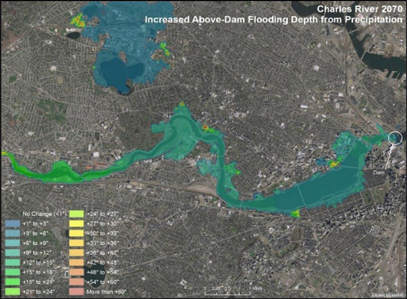
Charles River 2070

Location: Commonwealth of Massachusetts
Client: MASSDOT Highway Division

Project Characteristics

  • Climate change assessment and projections
  • Development of storm climatology for 20th and 21st centuries
  • Coupled wave and hydrodynamic modeling
  • Combined sea level rise and storm surge risk to critical infrastructure and assets
  • Cost estimations for engineering alternatives
  • Recommended, phased engineering adaptations for sea level rise

Woods Hole Group has supported vulnerability assessments by measuring, modeling, and forecasting flooding due to storms, sea level rise, climate change influences, and combined effects.

A complete vulnerability assessment recognizes the dynamic physical processes and timing associated with storms, along with increasing risks of sea level rise and climate change.
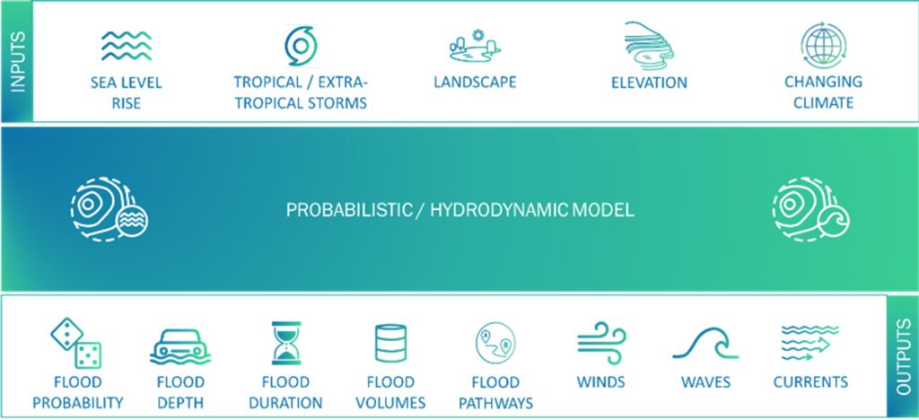
probabilistic / hydrodynamic model

Woods Hole Group has supported vulnerability assessments by measuring, modeling, and forecasting flooding due to storms, sea level rise, climate change influences, and combined effects

A complete vulnerability assessment recognizes the dynamic physical processes and timing associated with storms, along with increasing risks of sea level rise and climate change.

Woods Hole Group worked under contract to MassDOT to conduct a vulnerability assessment for all coastal transportation systems (roads, rail, airport, bridges, etc.) in the Commonwealth of Massachusetts.

Coastal Flood Risk Modeling

In order to determine the vulnerability of the systems, a highly resolved (less than 10 meters), numerical hydrodynamic model was developed to assess the combined impact of sea level rise, storm events (tropical and extra-tropical), winds, tides, river discharge, and waves. Tropical and extra tropical events were simulated using an ensemble Monte Carlo approach to develop probabilistic flooding distributions.

Results from the model were used to assess risk for assets throughout the transportation systems of the Commonwealth and to determine appropriate regional and site-specific adaptation designs to build resilience for the transportation networks.

Woods Hole Group designs coastal resiliency projects through an understanding of the storm surge that influences the site under both existing, and future, conditions.
Important factors such as the inundation depth levels, wave impacts, flood pathways, flood volumes, and probability of occurrence are all key considerations for developing cost-effective design approaches expected to function for current conditions, and perhaps more importantly, conditions occurring in a changing climate.

Additionally, the results are being used by numerous other stakeholders (e.g., health care, universities, water commissions) and communities to assess risk and develop resilient solutions.

Coastal Resilience Solutions for South Boston
Coastal Resilience Solutions for South Boston

Location: Boston, MA
Client: City of Boston

Project Characteristics

  • Sea Level Rise Assessment and Projections
  • Flood Pathway Analysis at High Resolution (street-level)
  • Combined Sea Level Rise and Storm Surge
    Risk to critical infrastructure and Assets
  • Coastal Engineering Resiliency Design
  • Public Engagement and Outreach
  • Recommended Design Flood Elevations
  • Development of Flexible, Phased Engineering Adaptations

Woods Hole Group was part of a multidisciplinary team that developed near-term and long-term strategies and engineering approaches for protecting South Boston from sea level rise and coastal flooding.  The project was led by the City of Boston Environment Department and the Boston Planning & Development Agency. Coastal Resilience Solutions for South Boston was the second neighborhood coastal resilience plan from Climate Ready Boston, the City of Boston’s ongoing initiative to adapt to climate change.

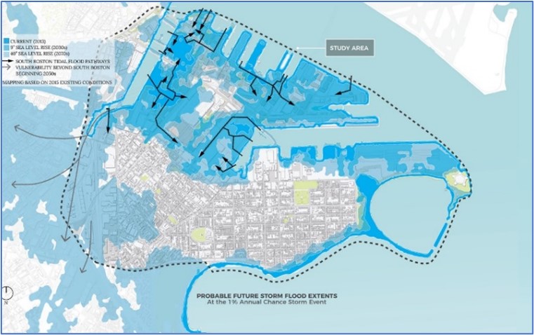
These study areas were selected because they are currently at risk from 1% annual chance coastal flooding and have high concentrations of vulnerable residents and critical infrastructure, as indicated by the Boston Harbor Flood Risk Model produced by Woods Hole Group and MassDOT.

The project involved extensive technical, design, and stakeholder engagement efforts, and Woods Hole Group was involved in all these efforts.

Woods Hole Group led the mapping of flood pathways, phasing strategies that accounted for evolving flood pathway dynamics, and development of resilient design criteria for future flood protection systems using results from the Boston Harbor Flood Risk Model.  Through iterative design and stakeholder engagement, potential flood protection strategies for critical locations were identified, evaluated, and developed. A set of evaluation criteria, established with input from stakeholders, guided the design process towards feasible, effective, and flexible solutions that achieve multiple benefits over long time horizons.

This project won the Boston Society of Landscape Architects 2020 Analysis & Planning Merit Award and the American Planning Association, Massachusetts Chapter 2019 Sustainability & Resiliency Award.

Coastal Flood Vulnerability Assessment - Town of Palm Beach

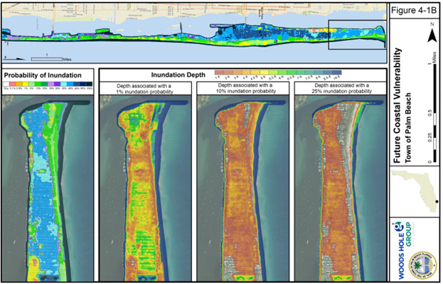
Future Coastal Vulnerability Palm Beach

Location: Palm Beach, Florida
Client: Town of Palm Beach

Project Characteristics

  • Combine the probability of inundation with the consequence score results in a coastal vulnerability index (CVI)
  • Methods applied are based on an award-winning, innovative, and quantitatively advanced probabilistic vulnerability model
  • Customized the model to the Town of Palm Beach
  • Designed to be integrated into the ongoing Town 10-Year coastal management program
  • Evaluated vulnerability of more than 2,200 Town-owned buildings, streets, parks, beach access ways, sewer pump/lift stations, stormwater basins and stormwater pumps

Woods Hole Group worked with the Town of Palm Beach (TOPB) to evaluate the threat that projected future changes in storm intensity and sea water levels pose to infrastructure in the Town.  The coastal vulnerability assessment is intended to provide guidance to the Town for prioritizing and planning future flood mitigation projects and adaptations to improve coastal resilience now and into the future. Ultimately, this assessment will help the Town improve its coastal resilience and help save money as projects are implemented to minimize costly flood damage and future repairs.

The assessment relied on a probabilistic, dynamic model developed specifically for the Town of Palm Beach.  This Palm Beach Flood Risk Model (PB-FRM) is a physics-based coastal flood model developed to determine the probability of flooding based on hundreds to thousands of storm scenarios.  The model outputs include the probabilities of inundation along with depth of flooding under present day conditions and a future scenario.  The model also provides numerous other quantitative parameters, such as wave information, wind information, currents, and flooding times based on the passage of coastal storm events.

The team evaluated the vulnerability of inundation for more than 2,200 Town-owned buildings, streets, parks, beach access ways, sewer pump/lift stations, stormwater basins and stormwater pumps. In a coastal vulnerability assessment, each asset considered is given a consequence score reflecting the value of an asset with respect to the impact on the community should it be damaged by flooding.

A standardized scoring approach was developed using six (6) criteria to produce a total consequence score for each asset.  The criteria utilized to determine the consequence score included:  impacts to public health & environment, cost of damage, impacts to economic activities, impacts to public safety services, area of service loss and duration of service loss.

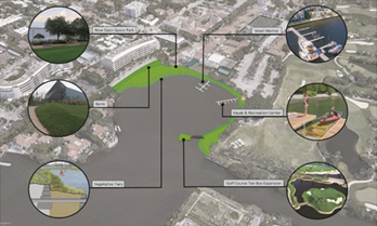
Evaluating Potential Adaptations for Vulnerable Embayments

Each of the 2,200+ Town public assets has a CVI, and the assets can be ranked from largest (most valued and most vulnerable) to smallest CVI.

With a comprehensive analysis of the probability of inundation for two time periods, depth of inundation for the same two time periods, standardized consequence scores for each asset and CVIs, the TOPB is positioned to make informed, defensible, efficient, and effective decisions for managing risk to TOPB public assets during present and future flooding events.

Currently, the Woods Hole Group Team is preparing an Implementation Plan to clearly define the path forward.  The Plan will build directly off the coastal vulnerability assessment by using the output to define specific action items and timing to optimize resilience and cost-effectiveness.

Implementation plans include both adaptations made in the short-term for particularly vulnerable and valued assets, as well as longer-term planning including monitoring, developing trigger points for action, and conceptualizing future adaptations.

An Implementation Plan also considers a range of possible adaptations at different scales.

Resilient Fort Point Channel Infrastructure Project Boston Planning & Development Agency (BPDA)

Future Coastal Vulnerability Palm Beach

Location: South Boston, MA
Client: Boston Planning and Development Agency

Project Characteristics

  • Permitting of Climate Ready South Boston design concept – MEPA Certificate
  • Hydrodynamic flood modeling of proposed coastal resilience infrastructure
  • Evaluation of independent flood protection effectiveness
  • Evaluation of impacts to abutters
  • Alternatives analysis
  • Identification of required environmental permits
  • Public and regulatory outreach materials
  • Site survey and point cloud data collection

Woods Hole Group helped the City of Boston and BPDA obtain a Certificate from the Massachusetts Environmental Policy Act (MEPA) Office for its first large-scale coastal flood resiliency implementation project. The project proposes to construct a $20 million, independently effective flood control system consisting of berms, raised Harborwalk, and deployable flood barrier systems to protect a large and vulnerable area of South Boston along the Fort Point Channel. MEPA approval was required as a precondition of obtaining $10 million in grant funding from FEMA for design and construction.

A key factor in the regulatory approval was Woods Hole Group’s coastal flood modeling performance analysis of the proposed project using the Boston Harbor Flood Risk Model (BH-FRM) – the City’s standard tool for coastal resiliency planning and design. The modeling demonstrated that the project is independently effective at controlling flooding through the major flood pathways and that it has no negative impacts on water levels, velocities, or waves on abutting properties. This analysis was done for present and future sea level conditions.

Woods Hole Group drafted and submitted the Environmental Notification Form (ENF) for the project in advance of regulatory changes that would have added to the project cost and schedule. The ENF application and accompanying narrative and plans covered issues such as existing conditions, historic resources, alternatives analysis, environmental permitting, stormwater management, climate change resiliency, and Environmental Justice, among others. Woods Hole Group also developed public and regulatory agency outreach materials and responses and presented at the public meeting for the project team.

Flood Insurance Study Appeal for Cameron Parish

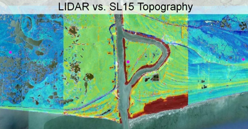
LIDAR vs SL15 topography

Location: Cameron Parish, LA
Client: Lonnie G. Harper and Associates, Inc.

Project Characteristics

  • Parish-Scale Review of Methodology Used to Determine Still Water Elevations
  • Assessment of ADCIRC Model Validation with Localized Focus on Cameron Parish.
  • ADCIRC Model Grid Assessment and Improvement
  • Conducted Simulations with Improved Model to Demonstrate Improved Accuracy
  • High Performance Computing

Woods Hole Group provided ADCIRC modeling expertise to assist Lonnie G. Harper and Associates, Inc. in their appeal of the preliminary Digital Flood Insurance Rate Map (DFIRM) for Cameron Parish, Louisiana. The appeal comprised a review of the methodology used to determine Still Water Elevations (SWELs) for Southwest Louisiana, identification of scientific and technical deficiencies, correction of deficiencies, and development of a plan to re-compute SWELs. The review revealed the ADCIRC model validation for the Southwest Louisiana Flood Insurance Study (FIS) was performed on a state-wide scale and does not necessarily ensure model accuracy at the local scale.  Model error was averaged over the entire state masking poor performance in certain areas. On average model accuracy was acceptable, but uniform accuracy was not guaranteed by the FIS methodology; particularly at the parish-wide scale where model results were applied to generate DFIRMs.

To assess the model accuracy within Cameron Parish, Woods Hole Group compared water levels observed during Hurricane Rita with those computed by the ADCIRC model as part of the model validation for the FIS. The comparison showed significant systematic error in the computed water levels within Cameron Parish; an unacceptable level of error according to FEMA guidelines. Water levels were under-predicted at the shoreline and over-predicted farther inland with errors greater than 5 feet in some locations.

Parish-scale review of model validation indicated the model should be improved through a localized assessment of model topography and frictional parameterization. A detailed comparison of the ADCIRC model grid with the best available elevation data at the time of the FIS revealed significant discrepancies between the model and actual topography in Cameron Parish. Also, an evaluation of frictional parameterization in the model with a localized focus on Cameron parish revealed potential for improvement of model accuracy through the elimination of systematic errors.

Based on these discrepancies Woods Hole Group revised the ADCIRC model, conducted sensitivity tests with varying frictional parameters, and re-ran the hurricane Rita validation simulation to demonstrate that enhanced model calibration and improved topographic accuracy yielded improved model performance. The revised model was recommended for re-computing SWELs used to develop the Cameron Parish DFIRM.

The appeal led to issuance of a revised DFIRM for Cameron Parish, Louisiana.